

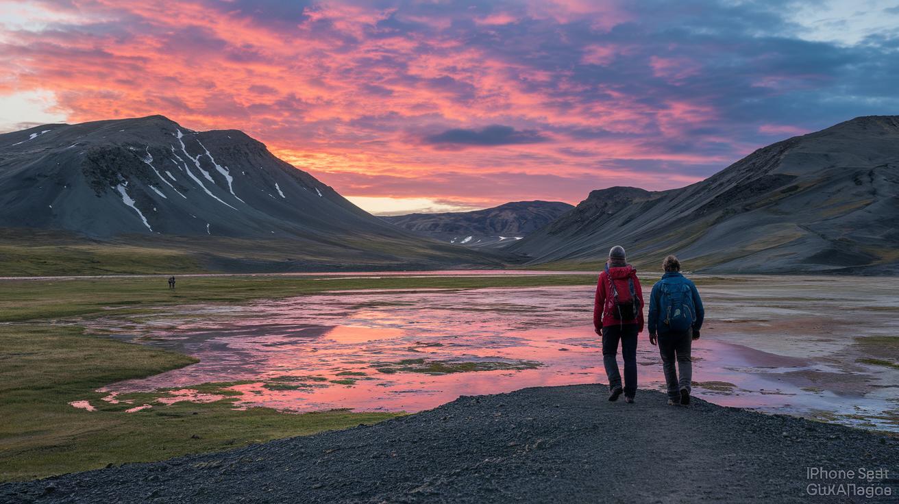
Ever wondered if a trail can change the way you see nature? The Laugavegur Trail in Iceland stretches about 55 km (34 miles) across rugged highlands. Expect bright mountain views, warm natural hot springs, and soft, mossy lava fields. From Landmannalaugar to Þórsmörk, every step brings a new story.
We’ve broken down this hike into simple tips. You can choose a guided trek or pack your own gear. Read on to see how this route might spark your next memorable mountain adventure.
Key Details for the Laugavegur Trail
The Laugavegur Trail runs about 34 miles (54.7 km) through Iceland’s rugged highlands. It starts at Landmannalaugar and leads you to Þórsmörk. Along the way, you’ll see bright rhyolite mountains, warm hot springs, swift glacial rivers, and lava fields covered in soft moss. Each step feels like a new chapter in an exciting adventure.
The trail is open from late June to mid-September when the highland F-roads can be used. This means you’ll need to plan your trip in summer when the days are long and the views are at their best. Every year, roughly 75,000 to 100,000 hikers enjoy this trail, with July and August being the busiest months.
You can choose to join a guided trek where your gear is hauled between huts, or you can set off on a self-guided hike carrying your own supplies. Both options suit different styles and make for an unforgettable journey in Iceland’s unique highlands.
Laugavegur Trail 4-Day Route Breakdown
On Day 1, you set out from Landmannalaugar toward Hrafntinnusker. You’ll cover about 12 km (7.4 mi) in 4–5 hours and climb roughly 470 m. Picture an early start as the colorful landscape of Landmannalaugar wakes up with you. The sunrise turns the rhyolite mountains into a canvas of brilliant colors.
Day 2 sees a change in scenery as you leave Hrafntinnusker and head down to Álftavatn (Swan Lake). In another 12 km (7.4 mi) over 4–5 hours, you descend 490 m. The mostly downhill path gives you a chance to catch your breath and take in the unique views of the cool thermal areas.
On Day 3, you continue from Álftavatn to Emstrur (Botnar). This leg covers 15 km (9.3 mi) in about 6–7 hours with a slight net descent of 40 m. It’s a good day to settle into the rhythm while noticing the gentle changes in the landscape.
Day 4 brings you from Emstrur to Þórsmörk. You’ll travel another 15 km (9.3 mi) in 6–7 hours and lose around 300 m in elevation. Start early to enjoy clear views and avoid the peak season crowds. Keep a steady pace and manage your time well for this final stretch.
- Typical daily pace: 7–10 miles in 5–7 hours
- Early starts help beat the crowds in July and August
Accommodation on the Laugavegur Trail
There are five mountain huts run by the Icelandic Touring Association along the trail at Hrafntinnusker, Álftavatn, Emstrur, Þórsmörk, and Porsmörk. Each hut has its own nearby campsite so you can choose between a warm hut or setting up your small tent close by. Wild camping is not allowed, so stick to these spots.
Reservations for the summer season open in January. If you're planning a hike in July or August when most visitors come, it's smart to book early. Think of it like having a reliable friend ready to offer shelter when you need a break after a long day on the trail.
A hut night costs around ISK 6,000 per person, and a campsite fee is roughly ISK 2,000. Many guided trips even include help with moving your gear from hut to hut. To make planning simple, check the online mountain hut booking system at https://hike2hut.com?p=98.
- Reservations start in January.
- Hut and campsite fees are fixed.
- Guided trips often include gear transfers.
Plan ahead and enjoy the comfort and convenience these stays offer on your highland trek.
Gear Checklist for the Laugavegur Trek
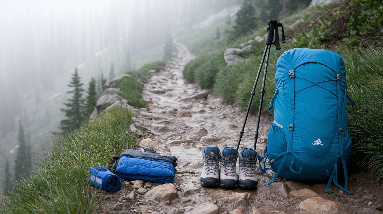
Plan your pack carefully and try to keep it light. The highland weather can change fast, so bring gear that works well together. Wear a moisture-wicking base layer, an insulating mid-layer, and a waterproof, breathable shell to keep you dry and safe. A good waterproof shell keeps you trekking securely even if a light rain turns the trail a bit slippery.
Make sure your shoes are tough enough for the trail. Sturdy hiking boots with ankle support are essential. If you need to cross cold, glacial streams, pack river shoes too. A 40–60 L backpack will hold your supplies without weighing you down, and trekking poles can help keep your balance on uneven ground.
Don’t forget the safety and comfort items you need. Pack a headlamp, a sleeping bag rated for -10 °C (14 °F) if you plan to camp, and a basic first aid kit with blister care, pain relievers, and an emergency blanket. Also, carry at least 3 L of water (with a filter or purification tablets) and high-calorie snacks to keep your energy up.
- Waterproof and breathable outer layer
- Insulating mid-layer and moisture-wicking base layer
- Sturdy hiking boots and river shoes
- 40–60 L backpack, trekking poles, headlamp
- Sleeping bag rated for -10 °C (14 °F)
- First aid kit, water filter, and high-calorie snacks
Weather and Seasonal Tips for the Laugavegur Trail
The weather on Laugavegur can change very quickly. In the summer, temperatures usually stay between 0 °C and 15 °C (32 °F to 59 °F). You might face strong winds, rain, or even a little snow. July and August offer more stable daylight and warmer days, making them great for most hikers. In June or September, you will see fewer people but could encounter more snow.
Before you set out, check local forecasts and live weather cams. Always bring layers so you can react to sudden changes. Pack a moisture-wicking base layer, a warm mid-layer, and a windproof outer jacket. This combination helps you stay comfortable, no matter how the weather shifts.
For early or late-season treks, carry microspikes or crampons (small metal tools that give extra grip on ice). This extra gear will help you keep your footing on icy patches and make your hike safer and more enjoyable.
Mapping Tools for the Laugavegur Trail
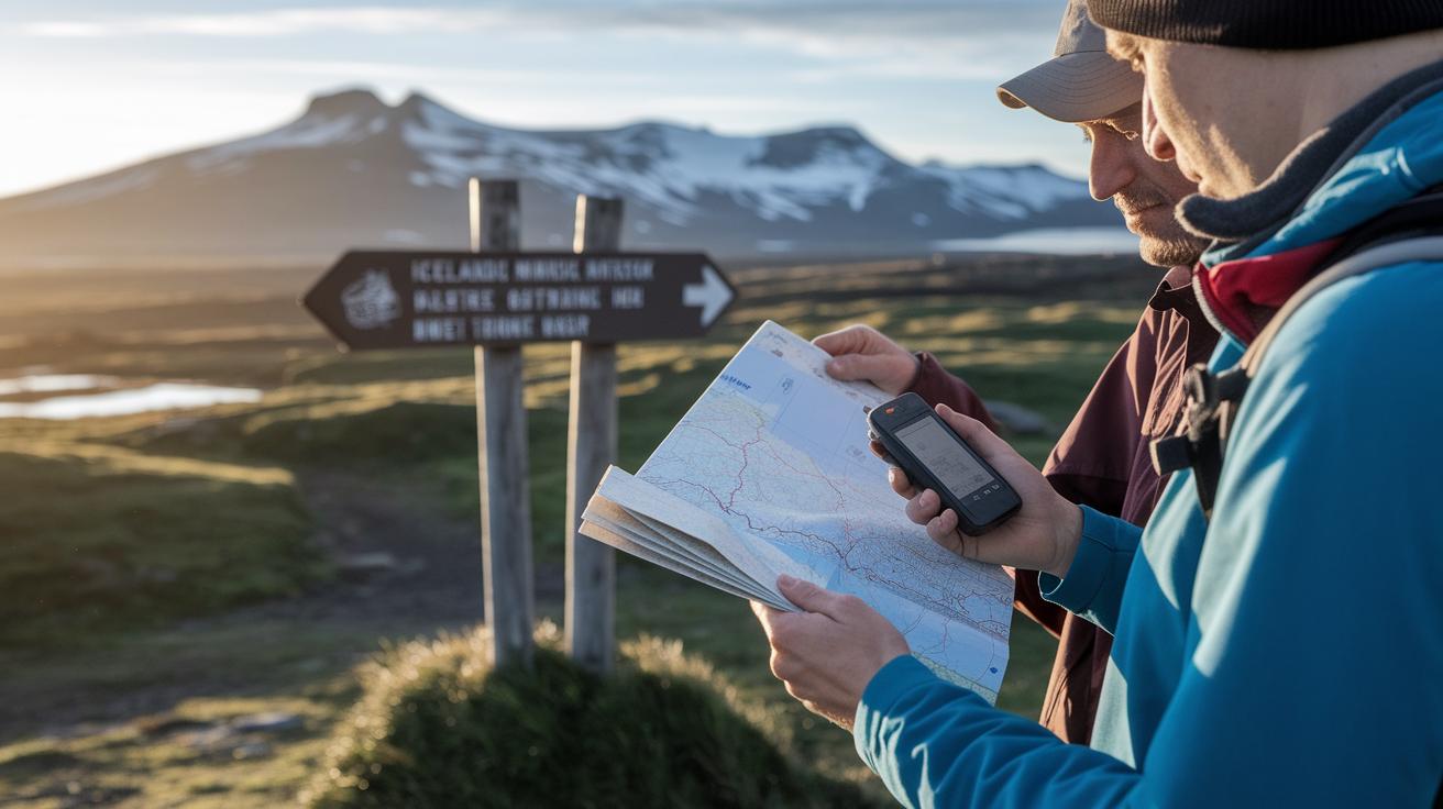
When you set out on the Laugavegur trail, it helps to carry a few mapping tools for your safety. The path has wooden signposts, but they are not enough on their own. Smartphone apps like Gaia GPS or AllTrails can load offline maps (maps you can use without cell service). One hiker said, "I looked at my app and saw the clear blue route, even when the mountains blocked the signal."
A dedicated GPS like the Garmin inReach Mini also works well. It gives you a clear position and lets you send a help signal if you get into trouble. Still, digital tools can sometimes fail. That is why you should also carry a compass and a printed map from the Icelandic Touring Association. This extra gear gives you peace of mind on an unpredictable trail. You can even check a gps hiking app for the latest offline maps before you leave.
| Tool Type | Example | Role |
|---|---|---|
| Smartphone App | Gaia GPS / AllTrails | Offline terrain data |
| Dedicated GPS | Garmin inReach Mini | Reliable positioning |
| Paper Map | Printed PDF from FÍ | Backup when digital fails |
Safety and Emergency Guidelines for the Laugavegur Hike
Rivers along Laugavegur can change quickly. Some crossings have good footbridges. Others require you to step carefully in the water using water-shoes and a trekking pole. Always check the river’s depth and flow before you cross. Carry an emergency locator beacon or satellite messenger. This small device can be a lifeline when you need urgent help in remote spots, especially where your cell phone might not work.
Pack a first aid kit that covers sprains, blisters, hypothermia, and other minor injuries. One hiker once said, "My kit helped me manage a painful blister and kept me on track." Allow extra time for weather delays or tricky sections and let a friend or family member know your daily plan and expected stop time.
- River crossings: Check water depth and flow. Be extra careful if there is no footbridge.
- Communication: Bring an emergency beacon or satellite messenger.
- First aid: Make sure your kit has supplies for sprains, blisters, and hypothermia.
- Group vs solo: If you are hiking alone, plan for extra time and keep others informed.
Stick together in difficult crossings and consider small groups to lower your risk during the more challenging parts of the hike.
Sustainability Practices on the Laugavegur Trail
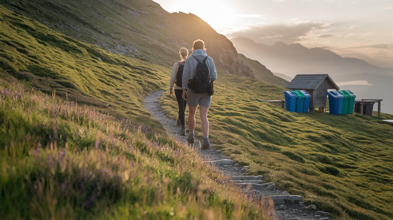
Every year, 75,000 to 100,000 hikers walk this route. Each step can hurt the soft moss and upset the hot springs if we're not careful. Camping is allowed only at spots marked for it, like approved FÍ campsites. Wild camping is off limits to protect these special areas. Always pack out your trash and food scraps, and use recycling bins in the huts where you can. Little actions like these keep the trail beautiful for everyone.
Stick to the marked paths. This helps protect the plants and stops the trail from wearing away. By staying on the trail, you help keep the delicate ground and wildflowers safe for future hikers. Before heading out, check local updates to see if any parts are closed for protection.
One hiker shared, "I felt proud cleaning up as I went, knowing my actions helped protect this incredible land."
- Pack out all waste and food scraps
- Camp only at designated FÍ sites
- Stick to marked trails
- Review conservation updates before trekking
Budgeting and Logistics for the Laugavegur Trail
For a four-day, self-guided hike on Laugavegur, plan to spend about ISK 100,000–120,000 (roughly $700–$800) per person. This covers hut fees (around ISK 6,000 per night), campsite fees (about ISK 2,000 per night), and meals (roughly ISK 1,000–1,500 each).
Transportation plays a big role too. Highland buses run from Reykjavík’s BSÍ station to Landmannalaugar and back from Þórsmörk for about ISK 5,000 each way. If you want more control over your timing, you can rent a vehicle that’s allowed on F-roads. There are also ferries or shuttle services at certain stops to help you get between trail segments.
Since parking in Þórsmörk is limited, booking a shuttle ahead of time is a smart move. This way, you can focus on the stunning Icelandic views and enjoy the adventure without any travel hiccups.
Final Words
In the action, we covered the highlights of your hut-to-hut experience. You read about route details, a four-day plan, booking tips, and gear must-haves. We outlined weather, mapping tools, safety steps, eco-friendly practices, and budgeting logistics.
Each section builds your confidence for this self-guided or supported trek. The laugavegur trail offers a safe, clear, and memorable highland trek that awaits your footsteps. Enjoy every step and embrace a well-planned, positive mountain escape.
FAQ
What does the Laugavegur trail cost?
The Laugavegur trail cost covers hut fees (about ISK 6,000 per night), campsite fees (around ISK 2,000), bus fares, and food, totaling roughly ISK 100,000–120,000 (~$700–$800) for a self-guided four-day hike.
What does the Laugavegur trail map provide?
The Laugavegur trail map is available in downloadable PDF formats from the Icelandic Touring Association and through interactive online maps. Popular hiking apps also offer offline maps for route guidance.
What do Laugavegur trail deaths indicate?
Laugavegur trail deaths remind us that highland conditions can be challenging. They stress the need to monitor weather updates, use proper gear, and plan for emergencies while respecting the rugged terrain.
What are the Laugavegur trail huts like?
The Laugavegur trail huts, run by the Icelandic Touring Association, offer basic accommodations with shared facilities and nearby campsites. They provide safe shelter for hikers at an estimated cost of ISK 6,000 per person per night.
What insights can Laugavegur trail Reddit offer?
Laugavegur trail Reddit threads provide firsthand experiences, route tips, and gear advice from hikers. They serve as a good resource to learn about current trail conditions and practical recommendations.
What does a self-guided Laugavegur trail hike entail?
A self-guided hike on the Laugavegur trail means carrying your own supplies and relying on maps, apps, and guide blogs. It is ideal for experienced hikers who can manage route details and variable weather conditions.
How do Laugavegur trail blogs help hikers?
Laugavegur trail blogs share personal insights, detailed itineraries, gear checklists, and local recommendations. They offer real-world advice and can help you plan your trek more confidently.
What is meant by a Laugavegur trail extension?
A Laugavegur trail extension allows hikers to explore additional routes beyond the classic four-day trek. It offers extra opportunities to experience Iceland’s diverse highland landscapes in more depth.
Can you hike Laugavegur without a guide?
You can hike Laugavegur without a guide if you’re experienced, prepared, and confident with using maps and navigation tools. Solo hikers should plan carefully and monitor weather forecasts closely.
What is the Laugavegur trail?
The Laugavegur trail is a famous multi-day route through Iceland’s Central Highlands. It covers about 34 miles (54.7 km) of diverse terrain including rhyolite mountains, hot springs, and extensive lava fields.
Do you need a permit for the Laugavegur trail?
You do not need a permit to hike the Laugavegur trail, but you must reserve your mountain hut accommodation in advance using the designated online booking platform. Wild camping is strictly prohibited.
What can you tell me about huts like Hvanngil, Fimmvörðuháls, and Hrafntinnusker?
Huts such as Hvanngil, Fimmvörðuháls, and Hrafntinnusker are key stops along the route that offer basic shelter. Additionally, Landmannalaugar Camping and Álftavatn Hut serve as starting and mid-route accommodations respectively, each following strict booking guidelines.